Tropical Storm Ophelia on track to impact NYC, NJ – like a hurricane but ‘cooler’
Sept. 22, 2023, 4:44 p.m.
Tree branches will be a major threat, along with riptides, storm surge and rain.
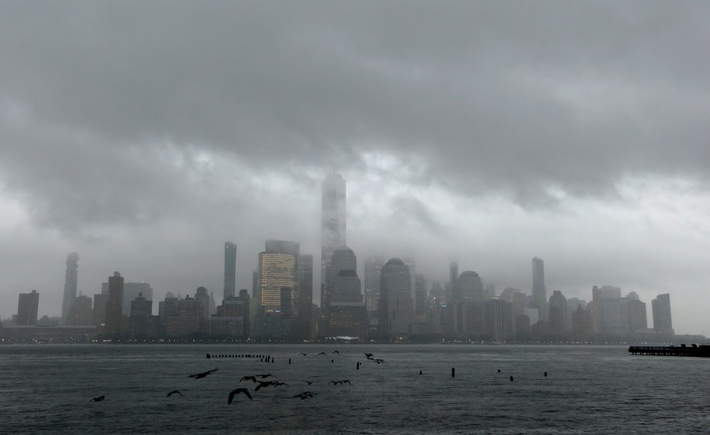
A subtropical storm that’s been quietly strengthening off the East Coast most of the week reached tropical storm status Friday afternoon, just in time to ruin New York and New Jersey weekends with a steady rain and hazardous gusty winds.
Tropical Storm Ophelia’s most hazardous conditions will make landfall on North Carolina and Virginia, but the storm is big — about 380 miles across east to west and 296 miles north to south in terms of the extent of its winds. It’s slated to gradually move northward after making landfall.
National Weather Service meteorologists expect New Jersey to see tougher conditions relative to downstate New York, but this entire region will likely encounter tropical-storm-force wind gusts. They said, given it’s autumn and most leaves are yet to fall, the timing of this storm carries an extra risk of large branches falling, which is a danger to people and power lines.
“You typically see a little bit more tree damage when you have full leaves on the trees than if it's in the middle of winter and you don't have any leaves,” said Sarah Johnson, a warning coordination meteorologist at NWS Mount Holly. The leaves make the branches heavier and more likely to catch the wind.
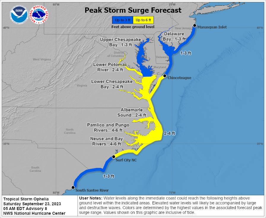
Ophelia will also deliver storm surge, high surf and rip tides — with the risks being greatest in South Jersey but still present around New York coastal areas.
Another thing people should know about Ophelia is that it started off with cooler temperatures than a typical tropical storm, but that didn’t stop it from rapidly strengthening due this year’s stretch of abnormally warm ocean water.
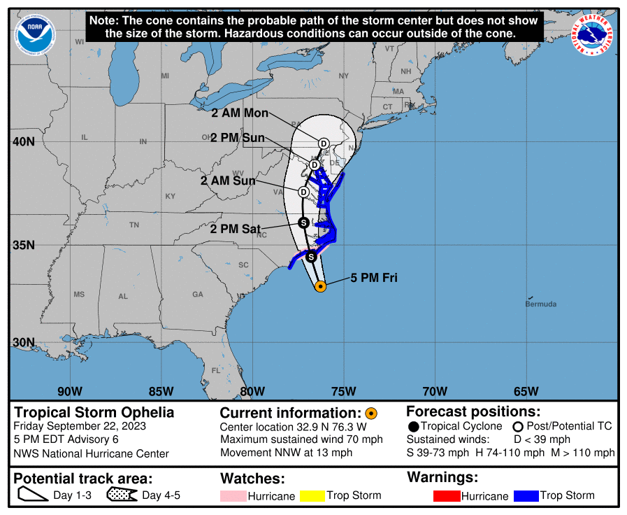
What to expect and where to expect it
Rain
As of Friday afternoon, forecasts call for rain to start in the tristate area overnight into Saturday morning and continue through early next week. Parts of downstate New York will accumulate about 2 to 3 inches over the entire weekend. NWS New York lead meteorologist John Cristantello said the rain could be heavy at times, mainly during the second half of Saturday morning into the afternoon.
Outside of the storm surge and coastal flooding risk, he predicted any potential flooding in New York City to be minor and due to poor drainage in low-lying areas.
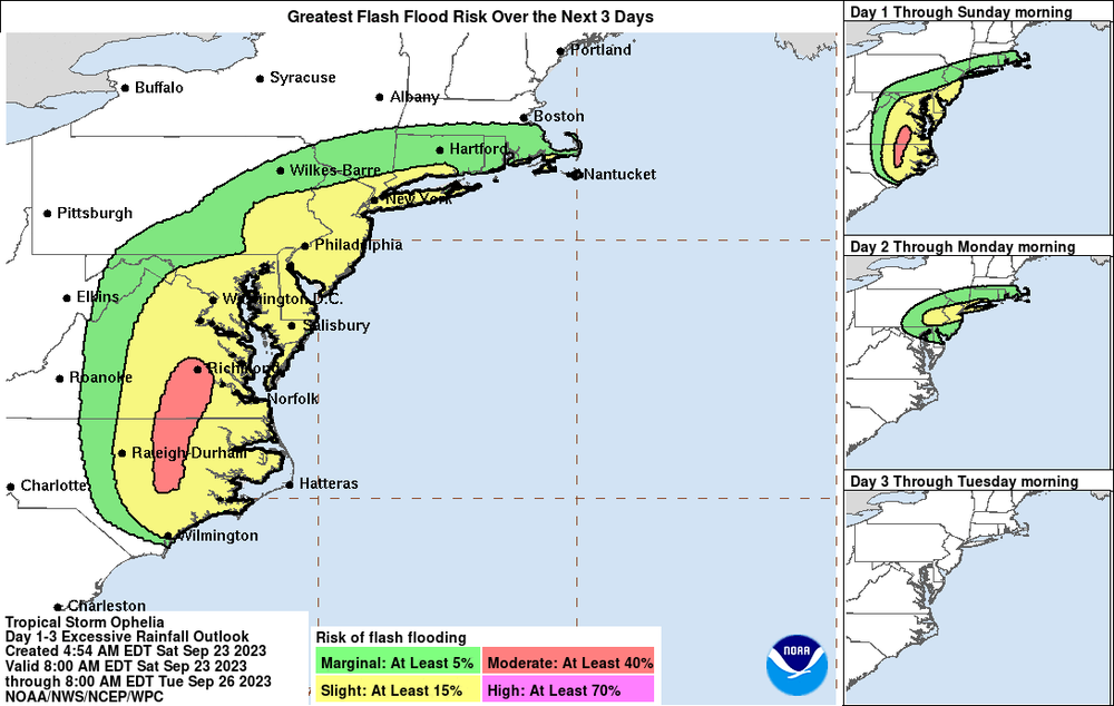
“Not really necessarily expecting flash flooding, but it's not completely out of the cards,” Cristantello said, “But it'll be more likely nuisance-type flooding.”
New Jersey will see 2 to 4 inches for the full weekend. Johnson said the heaviest rain will start to hit parts of South Jersey Friday night into Saturday, but North Jersey could feel it later Saturday into Sunday.. She said, as of Friday afternoon, it was hard to predict if flash flooding would occur due to uncertainty over how fast the rain could drop.
“When we're generally talking about flash flooding, it's not just about how much rain we get, but in how quick of a time that we get it,” Johnson added.
Cristantello said wet conditions could continue into Monday and that Tuesday was a better bet for a return to dry weather.
Wind
The strongest winds will begin to arrive Saturday morning and continue throughout the day.
The South Jersey coast could see wind gusts up to 60 miles per hour, Johnson said, while the North Jersey coast could see wind gusts up to 50 miles per hour during the height of the storm.
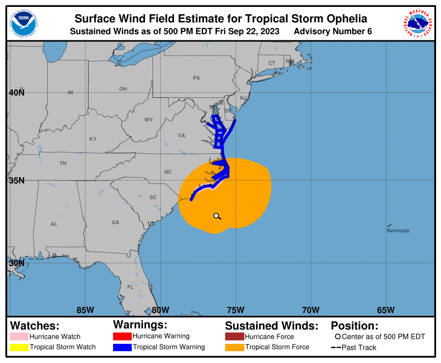
Inland areas in northern and central New Jersey could see gusts between 30 to 40 miles per hour, and these windspeeds are also predicted for New York City and Long Island, according to Cristantello.
To stay safe, Johnson recommended that people take some time to secure any loose objects outside, especially if you live in areas under wind advisories or high wind warnings
Coastal flooding
As of Friday afternoon, forecasters were confident that coastal and tidal flooding will be hitting New Jersey over the weekend.
“Basically for Barnegat Bay down to Cape May, we are looking at a likelihood of seeing moderate coastal flooding,” Johnson said. Areas farther north, such as Raritan Bay, NYC beaches and Long Island, will likely encounter minor flooding, but locals should be mindful of how the combination of the storm surge and high tide arriving later on Saturday might impact low-lying areas that routinely flood during rain events.
New York Governor Kathy Hochul and state emergency officials issued a warning on Thursday stating that they were monitoring the situation and ready to mobilize resources, and New Jersey Gov. Phil Murphy shared NWS alerts via social media on Friday.
The forecasts may also shift depending on how the storm behaves after making landfall. Updates and advisories on Ophelia are available via the National Hurricane Center, NWS New York and NWS Mount Holly for New Jersey.
How Ophelia started cool and grew hot
As their name suggests, most tropical storms begin in life in balmy waters of the tropics, where they can gain strength and occasionally become hurricanes. But Ophelia sprouted midweek off the Carolina coast as a subtropical storm, meaning it involved colder conditions outside of the tropics. That’s noteworthy due to the climate change-fueled heat wave that’s been present in the Atlantic Ocean for most of the year.
As NWS states in this explainer, the differences between a subtropical storm and tropical one are marginal. Both rotate like other cyclones. Historically, subtropical storms tend to carry less rain, but the same strength of winds.
But climate scientist Daniel Gilford said Ophelia could have strengthened rapidly because sea surface temperatures remain above normal off the Carolina coast. Direct study will be needed to determine any connection to climate change.
“Anywhere where the storm is feeling those warm waters, it has the potential to strengthen,” said Gilford, who works for Climate Central. Warm waters and rapid intensification featured recently in Hurricanes Lee and Idalia.
Less in doubt is the idea that Earth’s atmosphere is more moist now than a century ago — by about 10%, Gilford said, and that extra hydration in the air tends to get collected by storms.
“A warmer atmosphere is a wetter atmosphere, but that water has to come out when the storm starts to rain,” he added. “That increased water can be very damaging to areas that aren't prepared for it."
Research showed that Hurricane Ian had 10% more rainfall due to climate change and extra water vapor when it hit the U.S. in 2022. It also became the third costliest storm on record due in part to massive floods.
Ophelia and its cold core will also be accompanied by chillier air temperatures starting on Saturday, with daily Fahrenheit highs in the low- to mid-60s.
This story has been updated with maps, additional details about climate change and Daniel Gilford's affiliation.
2 years after Hurricane Ida deaths, are NYC's basement apartments any safer? 10 innovative ideas to help climate crisis on display at NYC science fair