The NYPD doesn’t report where it deploys police. So scientists used AI, dashcams to find out.
July 12, 2023, 11 a.m.
Cornell Tech researchers used nearly 25 million rideshare dashcam images to identify police cars on city streets and areas that receive more attention than others.
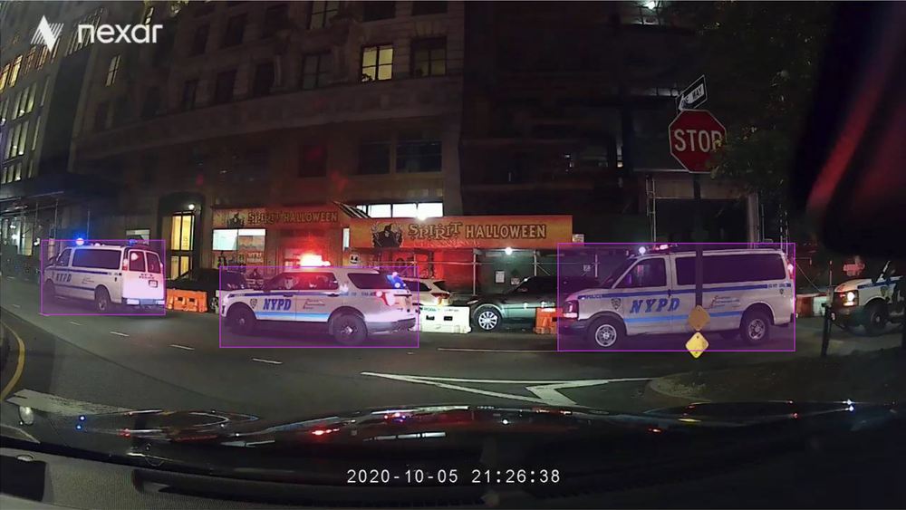
A team of researchers from Cornell Tech analyzed nearly 25 million dashboard camera photos from drivers for rideshare services — like Uber and Lyft — to identify where police cars are deployed in New York City. Their approach offers a new avenue to access info that the NYPD doesn’t release.
The authors found two major patterns of higher police deployment.
Looking at the citywide data as a whole, the highest deployment was in higher-income commercial areas, like Downtown Manhattan. And among residential areas, there was more deployment in low-income census tracts as well as in areas with higher Black and Latino populations, such the South Bronx and central Brooklyn.
The researchers also saw far more police vehicles in areas closer to police departments or Rikers Island, which they described as “unsurprising” in their paper. The study was released last month at the Association for Computing Machinery Conference on Fairness, Accountability, and Transparency in Chicago.
The Cornell Tech team used deep learning, an artificial intelligence technique that uses large sums of data to train a computer model to perform a task, in this analysis. After “teaching” the model how to identify police cars in a small group of example photos, it is able to identify the rest. In practice, deep learning requires fine-tuning to make sure it can perform a task accurately.
But for this model to predict whether the nearly 25 million photographs had police cars in them, the algorithms needed lots of examples — 9,449, to be exact.
The photos themselves came from Nexar, a dashcam company that sells to rideshare drivers. The company made the photographs available to researchers in 2020, and the images in question were taken throughout the five boroughs between March 4 and Nov. 15 of that year.
Matt Franchi, lead author of the study and a graduate student at Cornell Tech, spent six months fine-tuning the model to identify police cars from dashcam photos for the project. Only around 1 in 100 photographs had a police car, which Franchi described as “picking out needles in a haystack.”
“This kind of data is a gold mine for research on urban sensing [and] auditing of government services,” said Emma Pierson, assistant professor of computer science at Cornell Tech and a co-author of the study.
Franchi told Gothamist that if the NYPD released deployment data itself, this lengthy analysis wouldn’t be necessary in the first place. Outside of holding law enforcement accountable, the team had wanted to provide “preliminary evidence of disparities in police deployment,” Pierson said.
“The very computationally intensive and time-intensive way that we came up with an estimate of police deployment patterns could be completely skipped over if the police actually just released those deployment patterns,” Franchi said.
Publicly releasing that information, Franchi said, could help monitor whether policing in a region is equitable.

“The main call we’re making is that maybe this data should be more accessible,” Franchi said.
The NYPD did not reply to multiple requests for comment regarding why the data is not released.
Imani Henry, lead organizer for the affordable housing and police accountability organization Equality for Flatbush, said he’s “not surprised” by Cornell Tech’s findings — especially the detection of more police presence near Black and Latino residents.
“Where is the accountability and transparency?” Henry asked.
Dylan Hadfield-Menell, an artificial intelligence researcher and assistant professor at MIT, praised the researchers for their caution when creating their model.
When classifying data — like photos from dashcams in different locations — models can make more mistakes in some places than others, which introduces bias into the model.
But the researchers “were particularly careful about making sure that the errors weren’t biased across different demographics [in] different areas that they were collecting the data,” Hadfield-Menell said.
“This work is really interesting in that it’s creating metrics, but for public consumption,” he said. “There's a lot of opportunity to leverage the tools and techniques we have in order to build better public knowledge of what's actually going on.”
The data isn’t just useful for finding police. Cornell said the team had also analyzed images from dashcams to better understand social distancing in public spaces during the pandemic.
The team identified some limitations of their work. Their approach, for example, only looks at city street images, meaning that police officers in subway stations can’t be monitored. Many of those limitations, they explained, could be overcome if the NYPD released data itself.
NYPD says proactive approach has led to a drop in many major crimes Migratory birds love New York Harbor islands, but humans are forcing them out