NYC is sinking — but it's not because of large buildings
Oct. 3, 2023, 5:01 a.m.
New NASA research takes a closer look at why parts of New York City are sinking, offering a polite fact check to another study that went viral earlier this year.
New York City is sinking at a rate of a half-foot per century.
A new study released last Wednesday by a NASA-led research team used high-resolution satellite images to analyze the ground elevation of the approximately 300 square miles of New York City. This research was ostensibly following up a separate study published in May that hypothesized the city’s drop in land elevation — known as subsidence — was due in part to heavy concrete buildings pushing down on the Earth.
That conclusion was not quite right, though it drew a lot of headlines
The NASA team found that the city’s 1.68 trillion pounds of steel and stone had a negligible effect on sinking — unless structures were built on landfills, a fairly common practice in NYC. Hot spots for subsidence were spread out across the five boroughs.
Coney Island in Brooklyn, Arverne by the Sea in Queens and the Rikers Island prison complex were also built on landfill. The south side of Governors Island is basically a patch of landfill built on nearly 5 million cubic yards of rocks and dirt from excavations for the subway in the early 1900s. Just outside of the metropolitan area, New Jersey’s highways, Route 440 and Interstate 78, are sinking in areas built on fill.
Non-landfill areas where researchers detected sinking were mainly due to the melting of glacial ice sheets that once covered the region about 20,000 years ago. During the last Ice Age, New York City was located just outside a mile-high ice sheet that covered most of New England. The weight of the ice pushed down on the ground underneath while forming bulges on the edges that elevated the land. Those areas are slowly sinking back down over time.
“Much like a mattress, if you push down, you get a sort of depression underneath the mattress and then a bulge on the edge,” Robert Kopp, the study’s co-author and the co-director of the Rutgers University Office of Climate Action. “Those [bulges] come up as you lift yourself [off the mattress].”
The primary concern, researchers said, is how the sinking real estate will worsen coastal flooding as sea levels rise simultaneously because of climate change. Kopp said knowing how much the land is sinking alongside the rate of sea level rise is important for preparing and designing for the future.
Using satellites in space, the research team measured the annual changes in the height of the land from 2016 to 2023. They found that while the average rate of sinking is less than one-tenth of an inch per year, built-up landfill areas are sinking about three times faster.
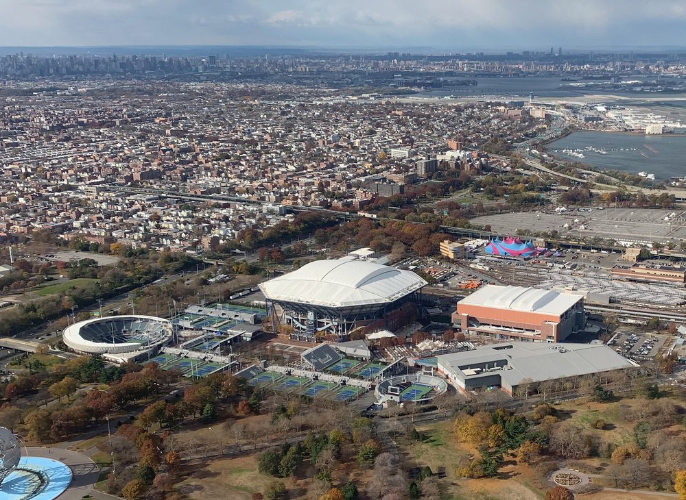
Hotspots like Arthur Ashe Tennis Stadium, which hosts the U.S. Open, and LaGuardia Airport, which transported 14.5 million passengers last year, are sinking by 0.15 and 0.18 inches, respectively.
“It is quite expected that these places would sink quite a bit faster because they're not building on hard structures,” said Brett Buzzanga, lead author of the study and a NASA researcher.
For nearly two centuries, water levels around New York City have been rising an average of 0.11 inches per year, equivalent to the average adult human toe nail growth over the course of a month.
Buzzanga said officials need to consider where land is sinking as they prepare for flooding and climate change.
Not everything in the Big Apple is sinking though. Some parts are rising, including the areas of Newtown Creek, East Williamsburg and Woodside.
“We weren’t sure what to make of those,” Kopp said.
“This is not something we've seen in other studies,” Buzzanga added.
Researchers suspect these areas of rising land are mostly due to human activities such as the environmental remediation at Newtown Creek, a federally designated toxic Superfund site. Kopp said these activities include groundwater pumping and injection wells for water pollution treatment. Underground construction for the city’s water system in Woodside could be another cause. The land there was rising by about 0.28 inches annually for the first four years of the study, and then suddenly ceased.
“That's telling you something about human activities, and we're not sure what, but that might be useful for environmental monitoring,” Kopp said.
Finding the cause of land uplift and sink will require deeper analysis and observation. NASA scientists plan to expand the project to cover all of North America and eventually to the entire planet.
NYC’s public hospitals to offer abortion pills via telehealth, despite uncertainty in courts Why it rained so hard: Ophelia returned to hit NYC with an Ida-level storm