An Interactive 'Then & Now' Map Of Greenwich Village
April 29, 2019, 3:20 p.m.
On the anniversary of the neighborhood's historical designation, a new map enhances self-guided walking tours, showing the neighborhood now and 50 years ago.
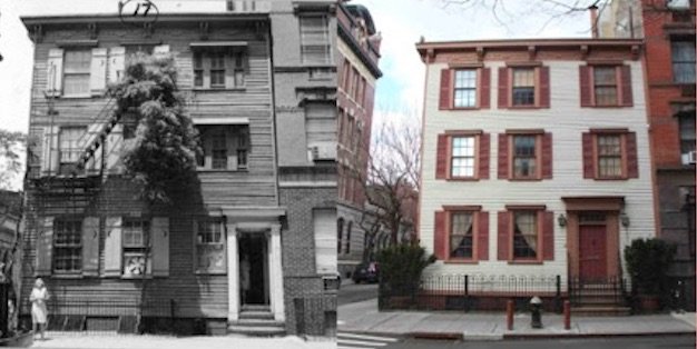
A wooden house located on 17 Grove Street, one of the many buildings in the GVSHP's new then and now map.
Fifty years ago today, New York City designated Greenwich Village as a historic district, citing its living history as an architectural and artistic haven. "The Village means something real, tangible and livable to its inhabitants while to the casual visitor, it represents a chance to look into a world of hidden charm, mystery and ever-changing vistas," reads the designation report from the time.
To commemorate the neighborhood's landmark designation 50 years on, the Greenwich Village Society for Historic Preservation released an interactive map that invites history buffs to poke around side-by-side comparisons of over 1,000 buildings in the area. Each point on the map features images of buildings pictured in 1969 vs. today, along with a designation report where you can learn more about the winding individual histories of buildings, parks, and other emblems of the neighborhood. “The Greenwich Village Historic District is one of the most historically, culturally, and architecturally rich places on earth, and we hope this new tool will allow native New Yorkers and people across the globe to engage with and appreciate the tremendous resource it provides," said Village Preservation Executive Director Andrew Berman in a statement.
In particular, the map encourages self-guided walking tours through the way it groups together the buildings—and by association, the stories—that have proved critical to how many communities, ideas, and policies have developed. For instance, the "Course of History Changed" tab details the place where the Manhattan street grid had its start (on Bleecker and Christopher Streets), the birthplace of the saying "heard it through the grapevine," and The New School building where W.E.B. du Bois and Gerda Lerner, respectively, taught the United States's first-ever African-American and Women's History Studies courses.
Scroll through the "Immigration Landmarks" section to read about how writer and artist Miné Okubo, who lived on 17 East 9th Street, shed light on the cruelties that Japanese-Americans suffered in internment camps in her sketchbook memoir Citizen 13660. There's a section, too, devoted to theaters of the Greenwich Village past. For those looking for the "Most Charming Spots" in the neighborhood, they've got you covered.
Unlike then and now maps showcasing stark differences between past and present, the Greenwich Village map is striking in that it shows how many buildings have been kept largely intact throughout years of change, thanks to preservationists and community groups whose efforts have helped keep them that way.
Expect to see even more photos, as well as these tours, on the site the coming months. In the meantime, enjoy a refreshing stroll peering up at historic facades that hopefully won't become a Lululemon or a Chase anytime soon.